Lake Level History

Lake Level History

     This graph show the historical lake levels for the last 60 years. We’re still trying to corroborate the all time high during hurricane Jeanne in 2004 because of some conflicting stories about how high the water was and the way data was taken then. However, note the dramatic changes. Johns Lake essentially functions like a reservoir or large retention pond. The trend is higher for the past decade but there has also been some very dry periods in 2001 & 2002 with just pockets of water here and there. This data does not include the current 2020 year with the level as of 10/7/20 at 97.40 NAVD.

Lake Vegetation Update

Lake Vegetation Update

The annual Lake Vegetation Index (LVI) survey was conducted by Orange County Department of Environment Protection in June of this year. The Lake Vegetation Index is a bioassessment procedure that measures the degree to which a freshwater lake supports a healthy, well-balanced plant community. Please see the sample locations below.

     Below is a graph that shows the past LVI scores for Johns Lake. In the past, the lake was separated into two different lake systems but after 2017 the lake was sampled as one unit. Due to the requirement to randomly select the sample locations and it is hard to tell if the impact of the County’s treatments versus the property owner removal treatments are impacting the overall score. There is a difference in the score for the eastern portion of the lake versus the western portion. This suggests that development along the lake may have an impact on the scores. The overall score for the lake in 2019 was 43. Scores 43 and above are considered good. Our score this year was 42.

No Data Found

Scrub Point Preserve

Scrub Point Preserve

Guest Author: Biagio Gugliotti (Lake County Water Authority)

     Scrub Point Preserve is owned and managed by the Lake County Water Authority. The Preserve is a 93-acre peninsula that juts into Johns Lake from the southern shore on the Lake County side of the lake. Ecologically, the site has been well preserved and there are at least seven threatened or endangered species and many endemic species (native species that occur in a limited geographic area). There are some exotic plant species, usually around the boundaries and along roads, which staff works to control. The staff has also used prescribed fire to manage some of the dryer habitats on the property. Fire is a very important tool for managing habitat for the rare and endemic species.

     Staff periodically leads field trips on the property. In the past, they have led trips for Festival of Flight and Flowers (formerly the Wings and Wildflowers Festival), and for groups like the Florida Native Plant Society. The Water Authority has also partnered with the Lake County Parks and Trails to lead kayaking trips leaving from the County boat ramp on Highway 50 and paddling across the lake to the Preserve. Staff would then lead a guided hike on the preserve before paddling back to the boat ramp.

     Currently, there is no public access from the land, but access is allowed by boat at the northern point. In recent months more and more boaters are using the preserve. It appears that during the Covid-19 outbreak, more people are socializing on their boats and watercraft since bars and other social venues are closed. Unfortunately, this is having a negative effect on the preserve. The preserve is opened from sunrise to sunset. Alcohol, pets, hunting, trapping, and camping are not allowed on the preserve. All plants, animals, and cultural and historic resources are protected. Some of the issues have been with alcohol and trash on the preserve. The other big issue is the native shoreline vegetation is being destroyed by boats. The original beach area at the point was about 40 feet wide and would accommodate 3-4 boats. As attendance has increased, the opening in the vegetation has become wider and wider.

     Staff installed signs (pictured below) on either side of the opening in an attempt to educate boaters and create a physical limit to the extent of the opening in the vegetation. Within a week of installation, both signs were torn down. Staff was able to relocate the signs in the water and reinstall them. At the time of this writing, one sign has been torn down a second time and the other was twisted around so that the sign was facing the shoreline. The Water Authority is also working with the Lake County Sheriffs Marine Unit to increase patrols of the area.

     The Water Authority wants the public to enjoy the natural beauty of the property, but please be respectful and follow the posted rules.

Johns Lake Outfall Study Update

Johns Lake Outfall Study Update

The Johns Lake Outfall Study is nearing completion. A company was hired by Orange County in January 2020 to evaluate the outfall connecting Johns Lake to Lake Apopka. The main elements of the study were to collect data and identify updates to the stormwater management system and drainage basin hydrology, model the stormwater of Johns Lake Basin and establish flood control Levels of Service, and develop alternatives to improve flood control and the capacity of the outfall channel.

A meeting was held on 9/16/20 with Orange County, the Town of Oakland, Johns Lake Improvement Association, and the hired company to go over the watershed lake management alternatives and options for facilitating the maintenance of the channel. Three options were presented and the advantages and disadvantages of each were discussed to gain feedback and input. Not all of the options provided enough relief in the event of a major flood event with unusually high water. The FEMA 100-year elevation of 99.7 maps shows the potential negative impact of very high water to the area. None of the options provide more than 6” of drawdown improvement over 60 days and no decisions were finalized.

Some of the potential challenges include:

  1. Cost – who bears the responsibility for capital and maintenance costs?
  2. Function – options to fund capital improvements and long term, grant possibilities, other agencies?
  3. Options- what other options are there?

The Town of Oakland expressed concerns about their small footprint relative to the overall size of the drainage basin and how whatever is done will affect so many people and properties. Orange County and the Town of Oakland have a Joint Planning agreement to address this topic, but the details have not been finalized.

Action Items and Next Steps:

  1. The hired company will prepare a summary
  2. Present their findings and recommendations to Johns Lake Advisory Board
  3. Discuss recommendations with St. Johns Water Management District to discuss permit requirements
  4. Complete the Final Report

As soon as the options are firmed up, we will share the plan with you.

Hydrilla Update

Hydrilla Update

Good news! The Florida Fish and Wildlife Conservation Commission reports that they have plans to treat the hydrilla on Johns Lake when the environmental conditions are favorable (lower water level and cooler temperature), hopefully in November. They plan to treat 250 acres along residential shorelines. Please see the highlighted areas outlined in yellow, not the colors in the open water but rather the yellow lines along the shorelines. The challenge might be the water level as we don’t see it coming down much by then and it may actually go up. It is now very close to the normal highwater mark. Anyway, we’ve told them we need this to be done ASAP.

20th Annual Johns Lake Holiday Boat Parade

20th Annual Johns Lake Holiday Boat Parade

This year is the 20th Annual Johns Lake Boat Parade! The event will be held on Sunday, December 13th at 6:15 PM. Come out and decorate your boat with lights and join in the fun! We usually have many spectators in their back yards, as well as at the public boat dock on Lake Boulevard in Winter Garden.

     All boats participating should gather by 6:10 PM in the NW corner of Johns Lake; otherwise known as Clear Lake (see map for exact location). THIS IS A NEW MEETING LOCATION FROM LAST YEAR. The lead boat will start the parade at 6:15 PM by blasting an air-horn several times. All boats should follow in-line and slowly head east. The parade route will follow the northern, eastern, and southern shores of Johns Lake (from Johns Lake Landing in Lake County to Twinwaters in Orange County, where the parade ends). The parade will take about 2 hours to complete. Please see the Parade Route Map.

If this is your first time decorating your boat for a parade, here are a few tips:

  • Christmas lights run on 120v AC and are designed to operate from your home electrical current. To operate lights on your boat, you will need to purchase a DC to AC power inverter. Power inverters are available at most auto parts stores, Wal-Mart, and Harbor Freight. Power inverters convert your boat’s 12v DC power to 120v AC. Inverters do have a limit as to how much power they can generate from your boat’s DC battery. Inverters are rated by watts; the more watts the inverter can handle, the more lights you can put on your boat. Most power inverters above 150 watts will need to be connected directly to your boat’s battery terminals to provide full power as 12v outlet plugs (cigarette lighters) are power limited by a fuse.

  • The use of LED lights provides the ability to power many more lights than incandescent lights. A 300-watt power inverter connected directly to your battery could power over 600 LED lights as opposed to 60 incandescent lights!  Be careful though, as some units will overheat if too much load is placed on them.  Test your lights for a period of time before the parade starts.  Make sure you use UL-approved outdoor lights as the lights on your boat may get wet and you do not want to cause a fire or shock someone on your boat!

  • If you do not live on the lake, you can view the boat parade from the public boat ramp on Johns Lake located at 13620 Lake Blvd., Winter Garden, FL 34787 (north shore of Johns Lake, off of Hwy. 50 at the Lake/Orange County line). The parade should be passing the ramp at approximately 6:45-7:15 PM. If you have any questions about the boat parade, please call Ann at 407-701-8033 for details.

Johns Lake Drainage Study Update

Johns Lake Drainage Study Update

In August of 2019, Orange County hired an independent company to evaluate the existing condition of the outfall canal connecting Johns Lake to Lake Apopka. The County, the Town of Oakland, and the Johns Lake Improvement Association have expressed concerns regarding the ability of this canal to adequately convey stormwater flows to Lake Apopka during wet periods without causing adverse impacts to property and infrastructure. The canal is more than a mile long and has a lot of trees and brush growing in it which requires regular maintenance

The steps identified were:

Step 1

Data collection and evaluation to identify relevant updates to the primary stormwater management system (PSMS) hydraulics and drainage basin hydrology.

On February 2, we received an update that shows they have been working on step 1 of Johns Lake models. So far, they have looked at the data from the 2001 study and are looking into the changes since that time. They are considering all the land-use changes, local road and highway changes including those proposed, and studying the lake levels since 1959. The data is currently being obtained and reviewed that will support the remaining steps of the Johns Lake Outfall Study and Conceptual Design.

Step 2

Stormwater modeling of the Johns Lake basin to establish the flood control limits provided by the existing PSMS.

Complete watershed evaluation and develop the project model. Proposed model methodologies include: Drainage basin numbers, storage-area relationships, and times of concentration for newly incorporated projects and developments (e.g., Oakland Park, Heritage Hills, Johns Landing, SR 429) will be used from the source models.

Step 3

Development and evaluation of alternatives to improve flood control in the vicinity of Johns Lake and the outfall channel with input from the County, the Town, and the Johns Lake Improvement Association.

Conceptual alternatives are being identified. Once they have identified the alternatives, they will hold a meeting to discuss these alternatives with stakeholders including the Johns Lake Improvement Association. Hopefully, this will occur by the end of the first quarter of 2020. A significant amount of work has been completed and we are hoping this will eventually improve the Johns Lake outflow in the long term.

2019 Johns Lake Holiday Boat Parade

2019 Johns Lake Holiday Boat Parade

     This past Holiday season we held the Boat Parade on Saturday evening instead of Sunday evening. In the past, we had as many as 42 boats in the parade, with the average being about 20-30 boats.  Sadly, this year we had only 10 boats to start the parade and only four at the finish. We moved the parade to Saturday in hopes of having better attendance.

     Although there were many spectators on the shore, there weren’t as many boats in the parade this year.  The weather wasn’t a factor, as the temperature was mild and there was no rain.  We believe the reason for this poor turnout is that many lakefront residents attend holiday parties and other activities on Saturdays leading up to Christmas.

     In consideration of the turnout this year, next year’s Parade will once again be held on a Sunday and be our 20th Holiday Boat Parade! Thank you to the lakefront residents that attended both on the water and onshore. 

Johns Lake Outfall Study

Johns Lake Outfall Study

Background

Johns Lake is part of a 26 square mile drainage basin where storm water collects and flows into Lake Apopka through a canal/ditch called an Outfall. In the case of Johns Lake, there are man-made structures, culverts and ditches that are used to allow Johns Lake to self-regulate extremes of lake water levels. Johns Lake “outfall” is primarily through a water channel to Lake Apopka as shown in the picture below.

If Johns Lake water levels cannot self-regulate then there are serious consequences:

  • Homes and land can flood
  • Piers and docks can be submerged
  • Agriculture surrounding the lake will suffer
  • Erosion can occur
  • Natural habitat and ecosystems are negatively affected
  • Public boat ramp access can be unsafe (authorities will close the ramp)
  • Parks and Conservation areas may close
  • Water sports and recreational activities may be impacted
  • “Tussocks”  (floating islands) can appear and migrate around the lake and cause damage

When water levels are at Normal High-Water Elevation (NHWE) and tropical storms or hurricanes occur at the same time these problems are more severe. There is a valid concern that Johns Lake is not currently draining as fast as it used to and not as fast as needed. Right now, this may not be a big problem, but the lake level could easily go above the normal high-water mark and potentially flood some of our homes and do damage to many of our docks.

The lake level is not controlled but is affected by the outfall size and condition. If the flow is restricted by developers or culverts/road crossings, then the lake will rise, if there are no restrictions at all the lake could get too low. Currently the area from the northeast corner of the lake, under the Florida Turnpike up to Highway 50 is severely overgrown, has not been maintained by anyone for more than a decade and the water level has been too high to do anything for the last few years.

The area from the Turnpike to highway 50 is subject to development within the Town of Oakland. The current culverts under Motamassek road will be replaced in 2023 and size determination is critical. The size and design of this whole Outfall Pathway is critical to the health of Johns Lake. Everyone should be concerned.

Maintaining the outfall has become an expensive and labor-intensive task involving heavy equipment and reassessment of the engineering and maintenance of the outfall is needed.

Outfall Study (First Steps) –

There are many stakeholders and government entities involved with various aspects of Johns Lake stewardship; here are just some:

  • Town of Oakland
  • City of Winter Garden
  • Orange County
  • Lake County
  • SJWMD (Saint John’s Water Management District)
  • FWC (Florida Wildlife Commission
  • Florida DEP (Department of Environmental Protection)
  • JLIA (Johns Lake Improvement Association)
  • Friends of Lake Apopka
  • Lake area residents
  • Owners of private property along the outfall

Thus, a study by a professional engineering company was commissioned to build consensus and have a workable plan going forward to maintain Johns Lake and protect the interests of all involved.  The timing of this is critical with several large land tracts south of Hwy 50 for sale, the area is subject to development/growth. This study is likewise critical to the residents of the lake to ensure water levels don’t become dangerously high during wet season storms/high water and that the lake doesn’t get too low.

On August 7, 2019 the Johns Lake Outfall Study Kickoff Meeting was held at the Orange County Public Works Storm Water Building.  Purpose of the meeting was to facilitate data needs with the Town of Oakland, communicate project objectives, and obtain feedback from both the Town of Oakland and Johns Lake Improvement Association (JLIA). Handouts and exhibits provided for discussion included an agenda and GIS map of the study area. The following provides a summary of the discussion. 

The objective of the meeting was to discuss the ultimate project objective, which is to provide the Town with a conceptual, implementable design alternative to help manage lake levels and flow out of Johns Lake, Lake Tilden, and Black Lake and alleviate local flooding. CDM Smith was selected to complete the data compilation effort of the current project phase, Task 1 Watershed Assessment. The focus is on the primary storm water system of the interconnected Johns Lake, Lake Tilden, and Black Lake and their outfall to Lake Apopka. 

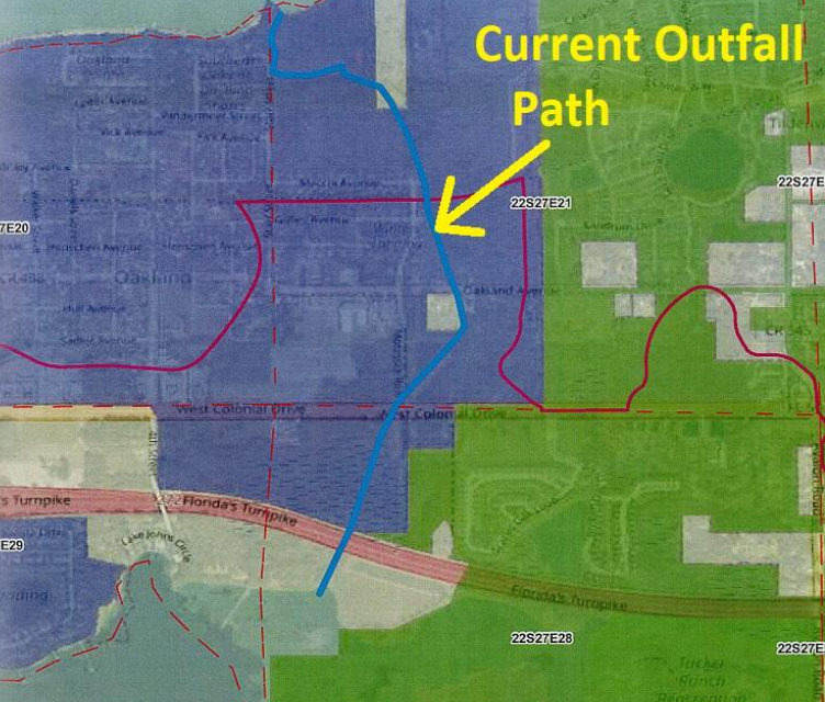
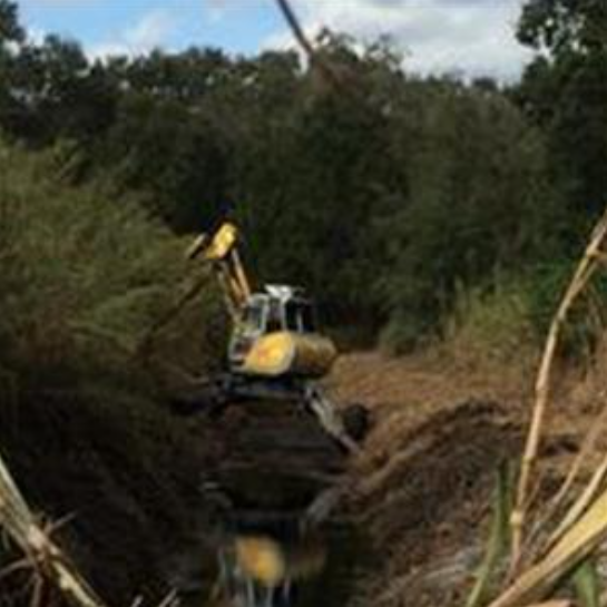
Town of Oakland Town Manager Stephen Koontz noted the concern over the Town’s ability to maintain the outfall “ditch”, especially as it is primarily on private property. Currently maintenance of the ditch is done by obtaining individual access agreements from each property owner.  Stephen also noted that ultimately the Town would like to determine whether any additional requirements should be included in their development codes to ensure no adverse impacts to the system from future development. Potential for joint agreements with neighboring municipalities and public agencies was discussed. City of Winter Garden may be a potential partner in maintaining the outfall canal. SJRWMD may be a potential partner if the project can provide some water quality benefits as Lake Apopka is an impaired waterbody. 

It was noted that fluctuation in lake levels is an important aspect for preserving habitats surrounding the lake. The conceptual design should consider this as it will likely be a concern for FWC. It was unknown whether there are any endangered species within the vicinity of Johns Lake. Johns Lake Improvement Association (JLIA) noted that grass carp are stocked in Johns Lake, but these fish cannot enter Lake Apopka. They are currently physically restricted from traveling into Lake Apopka due to the impediment of the control structure. Conceptual alternatives should maintain this restriction. Town of Oakland Public Works Director Michael Parker will be the contact for coordinating field reconnaissance efforts within the Town of Oakland. JLIA noted that structural flooding is not frequent though there have been instances during the 2004 hurricane season where structure flooding was reported. Piers and docks are frequently underwater. Michael Parker noted that the marsh land around Johns Lake has been dredged a few times and may be considered in the conceptual alternatives.

County Road 455 is currently under a PD&E (Planning Design & Engineering/Evaluation) to evaluate a potential design of extending the roadway and widening it to 4-lanes near the west end of the lake in Lake County and drainage from this roadway should be considered. Future progress meetings will include a meeting to discuss model results and a meeting to discuss the conceptual alternatives. A public meeting will also be held later in the project life to discuss the alternatives. 


Conclusion

This study is an exciting development as it will establish a means to justify budget and create design standards to keep Johns Lake a pristine body of water and a desirable place to live.  It will ensure that property values are maintained and environmental issues are addressed with a comprehensive approach.

Johns Lake Improvement Association will continue to liaison and maintain close contact with the stakeholders and monitor the study as the process evolves.   Residents can be assured that future newsletters will contain important information concerning this topic as things move forward.


19th Annual Johns Lake Holiday Boat Parade

19th Annual Johns Lake Holiday Boat Parade

This year is the 19th Annual Johns Lake Boat Parade! The event will be held on a SATURDAY this year, December 14th. Come out and decorate your boat with lights and join in the fun!

     All boats participating should gather by 6:00 PM in the SE corner of Johns Lake. THIS IS A NEW MEETING LOCATION FROM LAST YEAR. The lead boat will start the parade at 6:15 PM by blasting an air-horn several times. All boats should follow in-line and slowly head east. The parade route will follow the northern, eastern, and southern shores of Johns Lake (from Johns Lake Landing in Lake County to Twinwaters in Orange County, where the parade ends). The parade will take about 2 hours to complete. Please see the Parade Route Map.

If this is your first time decorating your boat for a parade, here are a few tips:

  • Christmas lights run on 120v AC and are designed to operate from your home electrical current. To operate lights on your boat, you will need to purchase a DC to AC power inverter. Power inverters are available at most auto parts stores, Wal-Mart, and Harbor Freight. Power inverters convert your boat’s 12v DC power to 120v AC. Inverters do have a limit as to how much power they can generate from your boat’s DC battery. Inverters are rated by watts; the more watts the inverter can handle, the more lights you can put on your boat. Most power inverters above 150 watts will need to be connected directly to your boat’s battery terminals to provide full power as 12v outlet plugs (cigarette lighters) are power limited by a fuse.

  • The use of LED lights provides the ability to power many more lights than incandescent lights. A 300-watt power inverter connected directly to your battery could power over 600 LED lights as opposed to 60 incandescent lights!  Be careful though, as some units will overheat if too much load is placed on them.  Test your lights for a period of time before the parade starts.  Make sure you use UL-approved outdoor lights as the lights on your boat may get wet and you do not want to cause a fire or shock someone on your boat!

  • If you do not live on the lake, you can view the boat parade from the public boat ramp on Johns Lake located at 13620 Lake Blvd., Winter Garden, FL 34787 (north shore of Johns Lake, off of Hwy. 50 at the Lake/Orange County line). The parade should be passing the ramp at approximately 7:30-8:00 PM. If you have any questions about the boat parade, please call Ann at 407-701-8033 for details.