May 3, 2021
Lake Level Data 4/21 Update
John Schmidt
Here is the latest lake level information; the graph shows the last 16 months thru April of 2021.
No Data Found


Non-profit devoted to the betterment of Johns Lake
May 3, 2021
Lake Level Data 4/21 Update
John Schmidt
Here is the latest lake level information; the graph shows the last 16 months thru April of 2021.
No Data Found
October 7, 2020
Lake Level History
John Schmidt
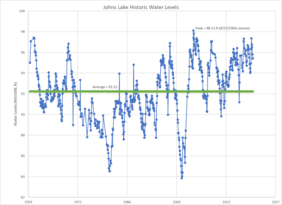
This graph show the historical lake levels for the last 60 years. We’re still trying to corroborate the all time high during hurricane Jeanne in 2004 because of some conflicting stories about how high the water was and the way data was taken then. However, note the dramatic changes. Johns Lake essentially functions like a reservoir or large retention pond. The trend is higher for the past decade but there has also been some very dry periods in 2001 & 2002 with just pockets of water here and there. This data does not include the current 2020 year with the level as of 10/7/20 at 97.40 NAVD.
October 1, 2019
Johns Lake Water Level Update
Rick Stuebing
Lake levels are measured by using the North American Vertical Datum of 1988 (NAVD 88). It is similar but not the same as measuring from “Sea Level”. The official recorded lake level as of September 20, 2019 was 96.70 feet above NAVD 88 and the Normal High Water Level is 97.36 NAVD 88. This level is less than one foot below the Normal High-Water Elevation.
Although variations in lake elevation are very good for the health of the lake and fish habitat if it gets too high it could flood some of our homes and cause damage to our docks.
February 25, 2019
Lake Levels
John Schmidt
The official recorded lake level as of January 2nd was 96.42
This is less than one foot below Normal High-Water Elevation. As you are aware this is pretty high for “dry season.”
As we’ve mentioned in prior newsletters, the outfall from the lake goes to Lake Apopka and the pathway is critical to control lake level. On one hand changes in elevation are very good for the health of the lake and fish habitat.
However, since this 39 square mile drainage basin must be capable of getting water out in periods of extreme weather, there might be some conditions that have changed that we are working to re-evaluate. On 2/19 we had a meeting with OC Commissioner Betsey VanderLey, Michael Drozeck Public Works Manager, Jeff Charles Drainage Project Manager, Mike Parker Town of Oakland Public Works Director, Steve Koontz Town of Oakland Manager and John Schmidt JLIA President to prioritize some of the issues we face on about the lake. We agreed that there is a need to update the Storm Water Drainage Basin data and particularly the flow rates. Some of the other issues we face are dependent on the results of this work and we cannot wait several years to get it done. Mike Drozeck will move this work up on the schedule and provide a timeline.
There is a Joint Planning Agreement that was signed in 2016 between Orange County and the Town of Oakland that also needs to be further developed around the “outfall ditch” to lake Apopka. The details around the specifics of who will handle the work, how easements will be obtained, who pays for the costs and so on were supposed to be worked out in three years. We are working with the various agencies to make sure our interests are taken in to account. This work is complex, will take some time, has budgetary concerns, and requires the updated study information already mentioned to be completed.
November 1, 2017
Brevard County’s Indian River Lagoon
J. Martin Davis, P.E.
In November 2016 voters in Brevard County, by a margin of over 63 percent, approved a half-cent sales tax to provide $302 million over a 10 year period to clean up the increasingly polluted waters of the Indian River Lagoon. This water body has been increasingly threatened over the past 5 years by fish kills, algae blooms and increasing levels of nitrogen and phosphorous. About two-thirds of the money will go toward removing muck from the bottom of the lagoon, estimated to be just under 5 million cubic yards. Another $62 million will be spent for septic system removal and sewer plant upgrades to supplement the loss of the septic systems.
At the risk of being overly alarmist, could there be parallels between the Indian River lagoon and Johns Lake? Population growth and the unending appeal of living on a body of water insures that development will continue on every available developable parcel on Johns Lake, just as it is occurring on the Indian River Lagoon. And, as we’ve explored in past Cattales issues (June 2016), several of the older communities on Johns Lake are on septic tanks, albeit the more recent development have been on sewer systems. We’ve also looked at the water quality parameters published by Florida Lakewatch since water sampling for Johns Lake began in 1989. This data indicated that the water quality parameters, including the all important nitrogen and phosphorous levels, have remained relatively stable.
A clue to this serendipity may lie on the graph of Johns Lake historical water levels, included below, which was also included in the last issue of Cattales.
No Data Found
You will note that lake levels appear to reach very low levels at approximately 20 to 25 year intervals, as evidenced by the low lake levels that occurred in 1980 and 2001 where the low water levels were around elevation 86 or less. It’s difficult to visualize the impact of this lake level until one sees, as is shown by the included aerial photo of Johns Lake, circa 2002, just how much of the lake bottom is exposed by these drought events.
But this fluctuation of water level in Johns Lake is actually a very beneficial and helpful attribute of our lake. See, Johns Lake does not have springs or streams that provide a constant source of water into the lake. Rather our lake relies on rainfall, runoff and groundwater levels to replenish and maintain lake water levels. As such, our lake water levels are quite variable, as variable as the Florida weather.
But this is actually a major benefit in terms of maintaining water quality. During these periodic dry spells and the ensuing drop in water levels, large swaths of the lake bottom are exposed to the drying effects of sun and wind on any accumulated muck that may have been deposited on the lake bottom, drying out and blowing away the muck that otherwise might remain and accumulate indefinitely. If the Indian River Lagoon had these fluctuating water levels, it is unlikely $200 million would now be spent on muck removal.
So, we’re golden, right. With this built-in environmental lake bottom vacuum cleaner we’ve got, we’re good
to go …right? I think not so fast. 50 years ago the environmental pollutants that now affect the Indian River
Lagoon were by and large unidentified, or at least ignored. Let’s keep our collective heads up lest we suffer
the same fate.