
October 1, 2019
Johns Lake Outfall Study
John Schmidt
Background
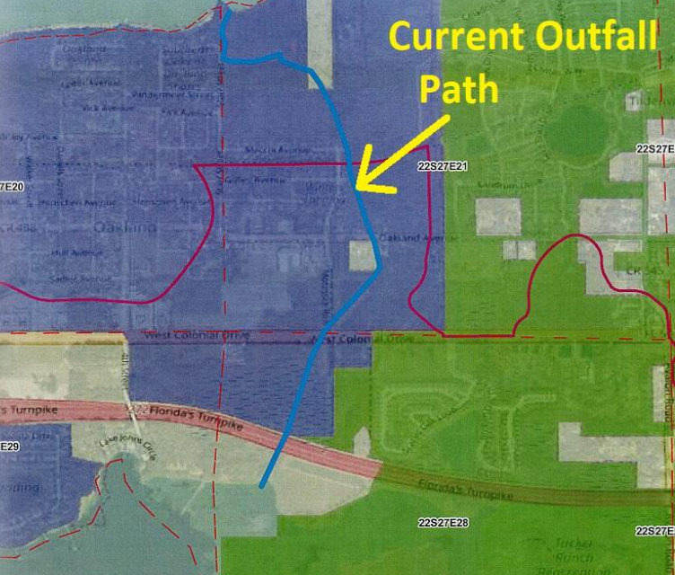
Johns Lake is part of a 26 square mile drainage basin where storm water collects and flows into Lake Apopka through a canal/ditch called an Outfall. In the case of Johns Lake, there are man-made structures, culverts and ditches that are used to allow Johns Lake to self-regulate extremes of lake water levels. Johns Lake “outfall” is primarily through a water channel to Lake Apopka as shown in the picture below.
If Johns Lake water levels cannot self-regulate then there are serious consequences:
- Homes and land can flood
- Piers and docks can be submerged
- Agriculture surrounding the lake will suffer
- Erosion can occur
- Natural habitat and ecosystems are negatively affected
- Public boat ramp access can be unsafe (authorities will close the ramp)
- Parks and Conservation areas may close
- Water sports and recreational activities may be impacted
- “Tussocks” (floating islands) can appear and migrate around the lake and cause damage
When water levels are at Normal High-Water Elevation (NHWE) and tropical storms or hurricanes occur at the same time these problems are more severe. There is a valid concern that Johns Lake is not currently draining as fast as it used to and not as fast as needed. Right now, this may not be a big problem, but the lake level could easily go above the normal high-water mark and potentially flood some of our homes and do damage to many of our docks.
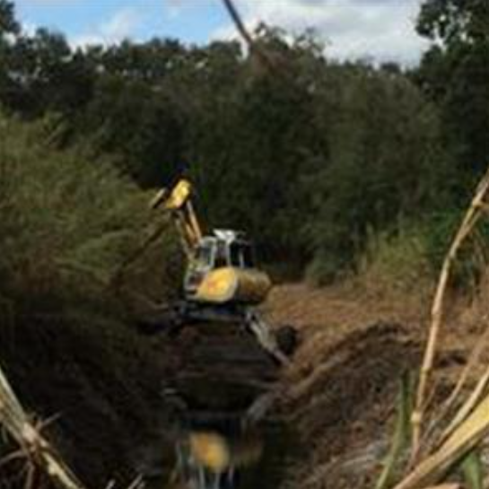
The lake level is not controlled but is affected by the outfall size and condition. If the flow is restricted by developers or culverts/road crossings, then the lake will rise, if there are no restrictions at all the lake could get too low. Currently the area from the northeast corner of the lake, under the Florida Turnpike up to Highway 50 is severely overgrown, has not been maintained by anyone for more than a decade and the water level has been too high to do anything for the last few years.
The area from the Turnpike to highway 50 is subject to development within the Town of Oakland. The current culverts under Motamassek road will be replaced in 2023 and size determination is critical. The size and design of this whole Outfall Pathway is critical to the health of Johns Lake. Everyone should be concerned.
Maintaining the outfall has become an expensive and labor-intensive task involving heavy equipment and reassessment of the engineering and maintenance of the outfall is needed.
Outfall Study (First Steps) –
There are many stakeholders and government entities involved with various aspects of Johns Lake stewardship; here are just some:
- Town of Oakland
- City of Winter Garden
- Orange County
- Lake County
- SJWMD (Saint John’s Water Management District)
- FWC (Florida Wildlife Commission
- Florida DEP (Department of Environmental Protection)
- JLIA (Johns Lake Improvement Association)
- Friends of Lake Apopka
- Lake area residents
- Owners of private property along the outfall
Thus, a study by a professional engineering company was commissioned to build consensus and have a workable plan going forward to maintain Johns Lake and protect the interests of all involved. The timing of this is critical with several large land tracts south of Hwy 50 for sale, the area is subject to development/growth. This study is likewise critical to the residents of the lake to ensure water levels don’t become dangerously high during wet season storms/high water and that the lake doesn’t get too low.
On August 7, 2019 the Johns Lake Outfall Study Kickoff Meeting was held at the Orange County Public Works Storm Water Building. Purpose of the meeting was to facilitate data needs with the Town of Oakland, communicate project objectives, and obtain feedback from both the Town of Oakland and Johns Lake Improvement Association (JLIA). Handouts and exhibits provided for discussion included an agenda and GIS map of the study area. The following provides a summary of the discussion.
The objective of the meeting was to discuss the ultimate project objective, which is to provide the Town with a conceptual, implementable design alternative to help manage lake levels and flow out of Johns Lake, Lake Tilden, and Black Lake and alleviate local flooding. CDM Smith was selected to complete the data compilation effort of the current project phase, Task 1 Watershed Assessment. The focus is on the primary storm water system of the interconnected Johns Lake, Lake Tilden, and Black Lake and their outfall to Lake Apopka.
Town of Oakland Town Manager Stephen Koontz noted the concern over the Town’s ability to maintain the outfall “ditch”, especially as it is primarily on private property. Currently maintenance of the ditch is done by obtaining individual access agreements from each property owner. Stephen also noted that ultimately the Town would like to determine whether any additional requirements should be included in their development codes to ensure no adverse impacts to the system from future development. Potential for joint agreements with neighboring municipalities and public agencies was discussed. City of Winter Garden may be a potential partner in maintaining the outfall canal. SJRWMD may be a potential partner if the project can provide some water quality benefits as Lake Apopka is an impaired waterbody.
It was noted that fluctuation in lake levels is an important aspect for preserving habitats surrounding the lake. The conceptual design should consider this as it will likely be a concern for FWC. It was unknown whether there are any endangered species within the vicinity of Johns Lake. Johns Lake Improvement Association (JLIA) noted that grass carp are stocked in Johns Lake, but these fish cannot enter Lake Apopka. They are currently physically restricted from traveling into Lake Apopka due to the impediment of the control structure. Conceptual alternatives should maintain this restriction. Town of Oakland Public Works Director Michael Parker will be the contact for coordinating field reconnaissance efforts within the Town of Oakland. JLIA noted that structural flooding is not frequent though there have been instances during the 2004 hurricane season where structure flooding was reported. Piers and docks are frequently underwater. Michael Parker noted that the marsh land around Johns Lake has been dredged a few times and may be considered in the conceptual alternatives.
County Road 455 is currently under a PD&E (Planning Design & Engineering/Evaluation) to evaluate a potential design of extending the roadway and widening it to 4-lanes near the west end of the lake in Lake County and drainage from this roadway should be considered. Future progress meetings will include a meeting to discuss model results and a meeting to discuss the conceptual alternatives. A public meeting will also be held later in the project life to discuss the alternatives.
Conclusion
This study is an exciting development as it will establish a means to justify budget and create design standards to keep Johns Lake a pristine body of water and a desirable place to live. It will ensure that property values are maintained and environmental issues are addressed with a comprehensive approach.
Johns Lake Improvement Association will continue to liaison and maintain close contact with the stakeholders and monitor the study as the process evolves. Residents can be assured that future newsletters will contain important information concerning this topic as things move forward.